Getting Out in San Francisco - Top 10 Trails

Ten trails for hikers or runners that show off the coastlines and old-growth forests of the Bay Area...
- - -
The trails of the Bay Area are paradise for any trail enthusiast, from day-hikers to outdoor-loving families to seasoned trail runners. And it's no mystery why; this area offers views from vistas overlooking the Pacific and the area’s waterways; the chance to spot wildlife, like whales and tule elk, and the cruiser singletrack that runs through towering redwoods, lush ferns, and coastal plains. The only downside is after hiking or running here, you’re almost guaranteed to be spoiled forever.
Here, 10 must-do hikes around the Bay Area.

Matt Davis-Steep Ravine Loop
One of the most popular routes in an area that has a strong trail running community, the Matt Davis Trail-Steep Ravine Loop provides well-constructed trails, a hefty climb (about 1,600 feet gained over 7.5 miles), and covers a variety of terrain: waterfalls, redwoods, canyons, grasslands, and plentiful views. Weaving through the foothills of Mount Tamalpais in Marin County, the trail is thick with hikers and visitors on weekends, so for more solitude, plan your outing for a weekday or early morning.
•Roundtrip Distance: 7.5mi // Elevation Gain: 1600ft
Bay Area Ridge Trail
Hikers and runners will find plenty to keep them happy on the 24-mile network of scenic trails on this former Army post, that’s forrested environs, ocean bluffs, and coastal views provide a starch contrast from the city life. One of the standouts from this trail system is the relatively flat, 2.5-mile Presidio section of the Bay Area Ridge Trail (which itself totals 338 miles of public use trail throughout the Bay Area). Highlights include; the public artwork piece, the Spire- a 90-foot sculpture made of 38 cypress trunks- old-growth forests, and views of the bay from the National Cemetery Overlook.
•Roundtrip Distance: 2.7mi // Elevation Gain: 150ft
East Ridge Trail to West Ridge Trail Loop from Skyline Blvd
Within the Redwood Regional Park, a worthy destination itself for outdoor lovers in the East Bay, the 8.4-mile East Ridge/ West Ridge Trail Loop is a popular loop showcasing the park's wide, grassy slopes, views of the rolling East Bay hills, and some of the few remaining stands of the 150-foot coastal redwoods. This trail offers moderate climbing, with just over 1,000 feet of elevation gain over it's course.
•Roundtrip Distance: 8.4mi // Elevation Gain: 1,062ft.
Sweeney Ridge Trail via Sneath Lane
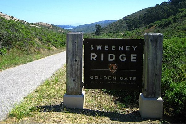
Ideal for tackling on a clear day, the Sweeney Ridge Trail offers coastal views, and historical appeal. Several trails lead to the very spot where Catalonian explorer Gaspar de Portola first discovered the San Francisco Bay in 1769, and there are also abandoned buildings from the 1950s. The Sneath Lane trailhead is a good starting point for a 3.9-mile hike to the top.
•Roundtrip Distance: 7.8mi // Elevation Gain: 1,676ft.

A versatile, eco-friendly, waterproof hiker, the FC 4.1 fits the bill for the varied terrain found on these Bay Area trails.
South San Francisco Sign
It might not have quite the renown as its southerly sister, the world-famous Hollywood sign, but the South San Francisco sign holds its own quirky appeal. Short and modersately steep, the hike to reach the white concrete letters, originally made out of limestone in the mid-1920s as part of a publicity push for the city, is just under 1.5 miles round trip. In 1996, Sign Hill, as it’s known, was placed on the National Register of Historic Places. Today, the 30-acre park makes for an easy urban adventure, with about two miles of hiking trails that offer views of the South Bay and San Francisco International Airport spread out below; it's especially scenic at sunset.
•Roundtrip Distance: 1.2mi // Elevation Gain: 364ft.
Mount Diablo Summit
Sitting at a modest 3,849 feet Mount Diablo’s summit isn’t one for the record books but is the highest peak in the Bay Area, and on clear days offer views as far as 200 miles. From the summit, spot a few of the area’s notable natural landmarks, including the Farallon Islands to the west; the 3,791-foot Mount Loma Prieta in the Santa Cruz Mountains to the south; and the snow-capped peaks of the Sierras. To reach the summit, the adaptly named 7.1-mile (round trip) Summit Trail gains just under 2,000 feet of elevation in 3.5 miles to the top of Mount Diablo.
•Roundtrip Distance: 7.1mi // Elevation Gain: 1,922ft
Mount Davidson

At 938 feet, Mount Davidson may be the highest peak in San Francisco's city limits, although neighboring Twin Peaks steals the spotlight, with tour buses and visitors constantly swarming its slopes. A few trails circling this hill are easily accessible through several neighborhood streets, but the Mount Davidson Trail is a 1.5-mile loop that offers a quick escape from crowded streets; grabbing lunch to go, bringing your dog, or making a few laps around the loop for a quick jog are the best ways to enjoy this urban trail.
•Roundtrip Distance: 1.5mi // Elevation Gain: 462ft
The Dipsea Trail

One of the most storied trails in the Bay Area, the Dipsea is a notoriously tricky route and host to the Dipsea Race, the oldest trail race in the U.S. The other 364 days of the year, the Dipsea still draws plenty of adventurers who scramble up and down its rugged, rooted terrain. Most runners and hikers opt to take the route from Mill Valley to Stinson Beach to get most of the uphill stretches out of the way first. As a point-to point trip, you’ll have to arrange transit accordingly.
For the full experience, start at the infamous Dipsea stairs: three sections of 688 of them (that’s the equivalent of about a 50-story building). From there, follow signs for the trail. It’s about 7.5 miles point-to-point, mostly uphill to the high point at 1,368 feet, when it begins to drop toward the Pacific. For the whole package, the Double Dipsea makes the course an out-and-back 13.7-mile haul that runs the course from Stinson Beach to Mill Valley and back, with 4,200 feet of total elevation gain.
•Roundtrip Distance: 7.5mi // Elevation Gain: 2,100ft

Tomales Point Trail
About an hour north of the city, the windswept sliver of land of Point Reyes National Seashore offers views of the coastline, wildlife, grasslands, and coastal trees, usually shrouded in a moody layer of fog. More than 150 miles of hiking trails provide plenty of options, but this 10-miler is a solid choice both for its scenery and relative accessibility. The trail starts at the historic Pierce Point Ranch and begins with a two-mile stretch to Windy Gap, where visitors can observe tule elk, 700-pound beasts that roam freely about the enclosed reserve through which the trail travels. From Windy Gap, continue for approximately three miles to reach the north tip of Tomales Point. Those who make it to the end will be rewarded with an overlook of the Pacific and Bodega Bay. The weather can be notoriously unpredictable; be sure to pack a light, waterproof shell and additional layers.
•Roundtrip Distance: 9.4mi // Elevation Gain: 1,190ft
Land’s End
Visit this popular trail on a weekdays to avoid tourist traffic, the 3.5-mile Land's End loop makes for a great run or walk, before or after work. The hills and steps offer enough of a challenge to break a sweat, but the views the Golden Gate Bridge provide an aesthetic backdrop for the exertion. For an extra calorie burn look, for a turnoff to the Mile Rock Beach viewpoint and its 100-odd steps down—keep a keen eye out for shipwrecks if it’s low tide.
•Roundtrip Distance: 3.5mi // Elevation Gain: 452ft
Originally written for La Sportiva by RootsRated.
Photos Provided by La Sportiva and RootsRated.


